![](/images/other/stat-length.png)
![Tocht Stappen Sant Julià de Vilatorta - Sant Julià de Vilatorta - Photo](https://media.geolcdn.com/t/1900/400/ext.pjpeg?maxdim=2&url=https%3A%2F%2Fstatic1.geolcdn.com%2Fsiteimages%2Fupload%2Ffiles%2F1553511878bg_sport_marche.png)
Sant Julià de Vilatorta
Didier343434
Gebruiker
![Lengte](/images/other/stat-length.png)
![Max. hoogte](https://static1.geolcdn.com/siteimages/upload/files/1508320355ic_sort_altitude_max_24dp.png)
![Positief hoogteverschil](https://static1.geolcdn.com/siteimages/upload/files/1508320355ic_sort_den_pos_24dp.png)
![Km-Effort](/images/other/stat-length.png)
![Min. hoogte](https://static1.geolcdn.com/siteimages/upload/files/1508320355ic_sort_altitude_min_24dp.png)
![Negatief hoogteverschil](https://static1.geolcdn.com/siteimages/upload/files/1508320355ic_sort_den_neg_24dp.png)
![Boucle](https://static1.geolcdn.com/siteimages/upload/files/16400158638029165_repeat_loop_refresh_sync_direction_icon.png)
![Stappen](https://static1.geolcdn.com/sitytour/trail-icons/101.png)
2h46
Moeilijkheid : Medium
![Mountainbike](https://static1.geolcdn.com/sitytour/trail-icons/202.png)
2h47
Moeilijkheid : Medium
![Scan deze QR-code om de tocht te openen in de SityTrail-applicatie](https://capi.geolives.com/qq0zvz2zws4bq2lad0pu/sitytour/trails/3342120/qr.png?size=200)
Gratisgps-wandelapplicatie
Over ons
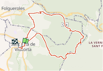
Tocht Stappen van 12,2 km beschikbaar op Catalonië, Barcelona, Sant Julià de Vilatorta. Deze tocht wordt voorgesteld door Didier343434.
Beschrijving
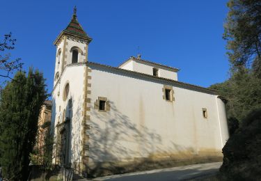
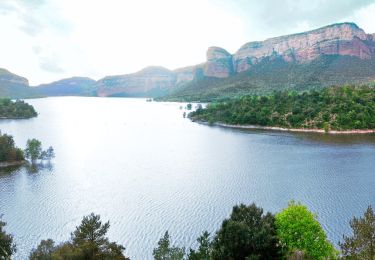
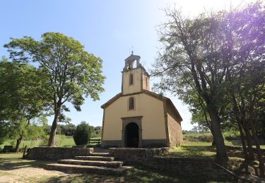
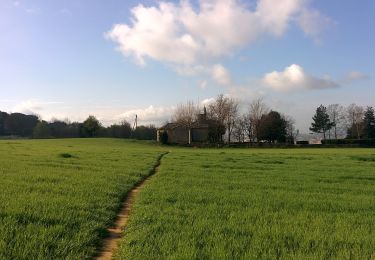
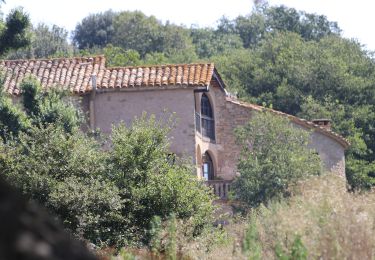
Belle et agréable route dans l'Espace Naturel des Guilleries - Savassona entouré de pâturages, de vues et de forêts. Le monastère de Sant Llorenç au sommet est très beau, bien qu'il ne soit pas possible de le visiter car il n'est pas ouvert au public. Il est recommandé de porter de bonnes chaussures de randonnée car certaines sections du chemin sont assez caillouteuses. Vaut la peine!
Plaatsbepaling
Opmerkingen
Wandeltochten in de omgeving
![Tocht Te voet Sant Julià de Vilatorta - Sant Julià de Vilatorta-Puig l'Agulla - Photo](https://media.geolcdn.com/t/375/260/70a1d118-d3d6-4c41-bc22-7ed2172e7158.jpeg&format=jpg&maxdim=2)
![Te voet Te voet](https://static1.geolcdn.com/sitytour/trail-icons/100.png)
Te voet
![](/images/other/stat-length.png)
![](https://static1.geolcdn.com/siteimages/upload/files/16400158638029165_repeat_loop_refresh_sync_direction_icon.png)
![Tocht Te voet Vilanova de Sau - Vilanova de Sau-Rupit - Photo](https://media.geolcdn.com/t/375/260/23ad58e0-c79e-4e23-a226-ead89b99f83f.jpeg&format=jpg&maxdim=2)
![Te voet Te voet](https://static1.geolcdn.com/sitytour/trail-icons/100.png)
Te voet
![](/images/other/stat-length.png)
![](https://static1.geolcdn.com/siteimages/upload/files/16400158638029165_repeat_loop_refresh_sync_direction_icon.png)
![Tocht Te voet Tavèrnoles - Folgueroles-Salt de la Minyona-Tavèrnoles - Photo](https://media.geolcdn.com/t/375/260/23ad58e0-c79e-4e23-a226-ead89b99f83f.jpeg&format=jpg&maxdim=2)
![Te voet Te voet](https://static1.geolcdn.com/sitytour/trail-icons/100.png)
Te voet
![](/images/other/stat-length.png)
![](https://static1.geolcdn.com/siteimages/upload/files/16400158638029165_repeat_loop_refresh_sync_direction_icon.png)
![Tocht Te voet Folgueroles - Folgueroles-Monòlits de Jacint Verdaguer - Photo](https://media.geolcdn.com/t/375/260/554d4686-3e9e-4283-ad21-015d9b206eb9.jpeg&format=jpg&maxdim=2)
![Te voet Te voet](https://static1.geolcdn.com/sitytour/trail-icons/100.png)
Te voet
![](/images/other/stat-length.png)
![](https://static1.geolcdn.com/siteimages/upload/files/16400158638029165_repeat_loop_refresh_sync_direction_icon.png)
![Tocht Te voet Folgueroles - Folgueroles-Sant Jordi de Puigseslloses - Photo](https://media.geolcdn.com/t/375/260/b5278c79-40c6-48e7-8f1a-b9838b7ebb51.jpeg&format=jpg&maxdim=2)
![Te voet Te voet](https://static1.geolcdn.com/sitytour/trail-icons/100.png)
Te voet
![](/images/other/stat-length.png)
![](https://static1.geolcdn.com/siteimages/upload/files/16400158638029165_repeat_loop_refresh_sync_direction_icon.png)
![Tocht Te voet Folgueroles - Folgueroles-Casol de Puigcastellet-Pla de Savassona - Photo](https://media.geolcdn.com/t/375/260/1a1ef6c9-8443-4e4f-8730-e4fa7346065b.jpeg&format=jpg&maxdim=2)
![Te voet Te voet](https://static1.geolcdn.com/sitytour/trail-icons/100.png)
Te voet
![](/images/other/stat-length.png)
![](https://static1.geolcdn.com/siteimages/upload/files/16400158638029165_repeat_loop_refresh_sync_direction_icon.png)
![Tocht Te voet Sant Julià de Vilatorta - La Font de la Riera - Photo](https://media.geolcdn.com/t/375/260/65a7a90e-6f3e-4717-88da-33277f886fc8.jpeg&format=jpg&maxdim=2)
![Te voet Te voet](https://static1.geolcdn.com/sitytour/trail-icons/100.png)
Te voet
![](/images/other/stat-length.png)
![](https://static1.geolcdn.com/siteimages/upload/files/16400158638029165_repeat_loop_refresh_sync_direction_icon.png)
![Tocht Te voet Folgueroles - Camins de Verdaguer - Photo](https://media.geolcdn.com/t/375/260/faa70fe2-3923-4f22-beb8-d6b977e9c34e.jpeg&format=jpg&maxdim=2)
![Te voet Te voet](https://static1.geolcdn.com/sitytour/trail-icons/100.png)
Te voet
![](/images/other/stat-length.png)
![](https://static1.geolcdn.com/siteimages/upload/files/16400158638029165_repeat_loop_refresh_sync_direction_icon.png)
![Tocht Te voet Folgueroles - SL-C 123 Folgueroles - Photo](https://media.geolcdn.com/t/375/260/1a1ef6c9-8443-4e4f-8730-e4fa7346065b.jpeg&format=jpg&maxdim=2)
![Te voet Te voet](https://static1.geolcdn.com/sitytour/trail-icons/100.png)
Te voet
![](/images/other/stat-length.png)
![](https://static1.geolcdn.com/siteimages/upload/files/16400158638029165_repeat_loop_refresh_sync_direction_icon.png)